|
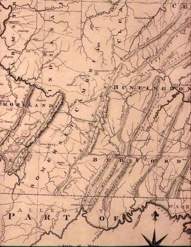
The county of Somerset was created April 17, 1795 from the western part of Bedford County lying between the Allegheny Mountain range to the Laurel Hill range, and was named for Somersetshire, England. It is bounded on the south by the Mason Dixon line and on the north by Cambria County, which was part of Somerset County prior to its formation in 1804. The highest elevation found in Pennsylvania is located in Somerset County and high elevations are consistent throughout the county. The area was included in the Indian Purchase of 1768 and became part of Cumberland County until 1771 when Bedford County was formed. Somerset, the county seat, was laid out in 1795, incorporated as a borough on March 5, 1804 and was located on the turnpike road leading from Bedford to Pittsburgh, now known at Route 31. The waters of the county drain through the Conemaugh River to the Allegheny River, the Casselman River to the Youghigheny River and through Wills Creek to the Potomac River at Cumberland, MD. Allegany County Maryland is also detailed on this map. Note that Garrett County has not yet been partitioned. Shortly after arriving in Western Pennsylvania, Christian Garlitz
II crossed the state line into Maryland and established himself in Allegany
County, east of what is now Grantsville, Garrett County.
|
|
1811 A MAP OF THE STATE OF PENNSYLVANIA BY READING HOWELL MDCCCXI, engraved by J. Vallance, Philada., published by Kimber & Conrad & Johnson & Warner. Howell issued this updated version of his smaller 1792 and 1795 maps in a larger size. The northeast showing the elusive county of Ontario and part of the southwest are shown here. The topography is precisely drawn, as are roads, towns, and important buildings. The northeast view has been enlarged to show the detail in Howell's map. The dedication cartouche has an agricultural motif. In the lower right the title cartouche is surrounded by a vignette illustrating different aspects of the state and including the state crest. In the lower left is a drawing of the Schuylkill permanent Bridge, no longer standing in 1811. See Phillips page 680. Longitude from Philadelphia. Blank verso. Scale: 1" = 10 miles. Size: 21 x 34 inches. |